This is Chapter Four of Sventlana Alpers' "The Art of Describing: Dutch Art in the Seventeenth Century", 1983
Quoted text is in YELLOW. Text quoted from other authors is in Orange
*************************************************************************** ****************************************************************************

Vermeer : The Art of Painting (1665-68)
With a complete map of the Netherlands in the background, this piece was chosen to begin Alpers' discussion of Dutch painting as map making.

As she notes, it's not just a functional map, but also the occasionally creased and peeling surface of it.


She also notes that the artist has placed his name (Ver Meer) on a horizontal stripe in the map - which may suggest that he identifies himself as a map maker.

The aim of Dutch painters was to capture on a surface a great range of knowledge and information about the world. They too employed words with their images. Like the mappers, they made additive
works that could not be taken in from a single viewing point. Theirs is not a window on the Italian model of art but rather, like a map, a surface on which is laid out an assemblage of the world.
Though in this painting, the map only serves a decorative function. It might just as well be a carpet, like the one in the foreground, for all it can tell us about the Netherlands. The creases and shadows are more important than any reference to geography.
It's far less about the world, than about how the artist enjoys re-creating it - in a context, by the way, in which no religious reference (other than Classical mythology) has been suggested.

Alpers also suggests that mapmaking carried over into making the kind of city profiles that can be seen around the borders of the map in "The Art of Painting" -- and also seen in Vermeer's "View of Delft":

Though one might note that so much more is happening in the above image. It may have started as a picture postcard, but it ended up as a great painting.
To blur the line between map making as a science or an art, Alpers points out the cartouche in the Vermeer's map.

Jasper Johns, "Map", 1963
..as well as this 20th C. painting which is something like a map of the United States.
It takes a certain Platonic way of thinking to get excited about the "true" meaning of words.
Alpers does not relate that discussion to how one feels when experiencing these paintings by either Vermeer or Johns.. But that philosophical excitement is certainly alive and well in in the contemporary art world
What should be of interest to students of maps and of pictures is not where the line
was drawn between them, but precisely the nature of their overlap, the basis of their resemblance.

One fascinating example would be this depiction of the 1572 siege of Harlem by Pieter Saenredam in 1628. It's something like a map - and something like an aerial view. The artist is better known for his interior views of Dutch churches.

Claes Van Visscher, Panorama of London, 1616 (detail)
Nowhere are the professional and pictorial links bertween pictures and maps closer han in the Visscher family


Here are some examples of Visscher's work. At the top is an etching taken from a painting mis-attributed to Bruegel. At the bottom is a rather ornate map of Belgium - which is strange and ugly enough to qualify as the outsider art of our time. The subsequent history of Belgium has exemplified this sad image of a "lion" that more resembles an abused dog.


At this point, we might consider this Spertus Museum online exhibit.
It quotes Harley and Woodward, "History of Cartography", to define maps as “graphic representations that facilitate a spatial understanding of things, concepts, conditions, processes or events in the human world.”. An extensive development of that idea can be found in the online edition of their books.
Applying that definition, I cannot find any reason not to include any representational painting or drawing within the category of maps. Though it does seem that the examples they show do not include graphics that might also be called portraits, landscapes, still-lifes, or narratives. Apparently "map" is a category like "porn". It cannot be defined - but you know it when you see it.

Here is the oldest surviving map of the Holy Land, the Madaba mosaic. As this detail would indicate, it shows the relative locations of important landmarks - as well as being quite decorative.


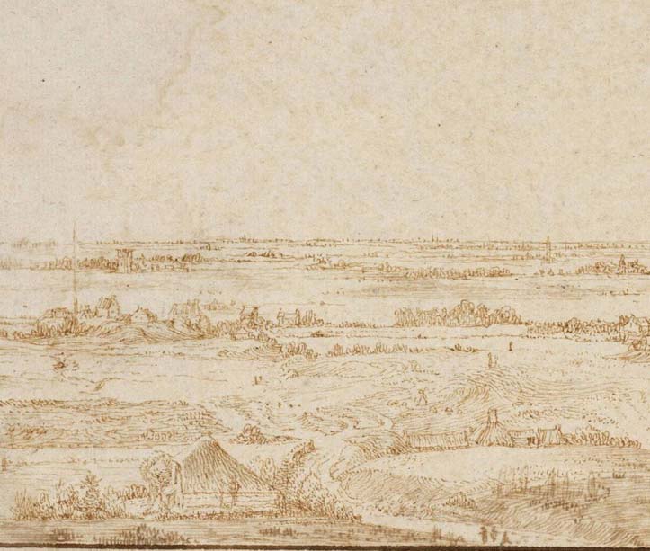
Jan Van Goyen, sketch and painting of Dordrecht
Getting back to Alpers, she notes how artists like Jan Van Goyen traveled to sites in order to "map" them, though the details in the sketch might be modified for the final painting.
The above examples were found online.
If you were familiar with the profile of Dordrecht, the painting would probably be as recognizable as the sketch (though we might question the accuracy of both)
The profile of the town is strongly asserted -- but still, it's only one form among many in the design. For us, the pattern of clouds might be the most compelling feature of the painting.


The above examples are by Hendrick Goltzius (1558-1617), whom Alpers tells us made the "first "realistic" Dutch landscape images" (though by her use of scare quotes, she suggests that such realism may not be as real as the effects of jumping off a roof)
She also tells us that "there is a lack of usual framing devices familiar in landscape representations which serve to place us and lead us in, so to speak, into the space"
Apparently the scenes with foreground figures were done earlier in his career, before he introduced a more map-like, panoramic view.

Thomas Cole, Autumn Twilight, 1834
I just saw an exhibit of the American Hudson River school, so it might be timely to think about whether the idea of "mapping" would apply any less to Thomas Cole.
It does appear that he was trying to portray an identifiable profile of those mountains in the background. And mapmaking was certainly an important practice on the frontier. His early supporter, Colonel John Trumbull, made maps for George Washington.
When I read about Cole's early training as a portrait painter, it seems to me that he was painting a portrait of the Catskill mountains.
One might also say that he was mapping them -- but I feel that he was portraying character - and that quality does not seem to apply to whether a representation can serve as a map or not.
The 17th C. Dutch paintings also seem to be serving as much more than maps.

Here's a Thomas Cole landscape drawing. As in the painting, the viewer is within the foreground, and a sharp break separates it from the middleground. Perhaps that is less "map-like".
As Alpers notes, Goltzius "makes us feel that we are situated apart from the land but with a privileged view"
With the Cole painting and drawing, the viewer is immersed in the landscape and/or invited to entet

Pieter Saenredam, Profile Views of Leiden and Haarlem and Two Trees, 1617 and 1625
Landscapes and mapping are linked to the Netherlands of the seventeenth century by the notion of what it is to draw. In the Italian dominated theory of the late 16th Century, drawing (disegno) had been exalted to the point where it was synonymous with the idea of art, and thus with the act of imagination itself. Hoogstraten, by contrast, introduces drawing as linked to letters formed in writing, to planning war maneuvers, to medicine, astronomy, natural history,and geography. Drawing is treated as a craft with specific functions , among which are the description on a page of different phenomena observed in the world.
Alpers offers the Saenredum drawing, shown above, as an example of one such descriptive page - including descriptions of a tree and city as well as calligraphy.


Though it might be noted that one notable Italian, Leonardo Da Vinci, also filled pages with sketches - including nature studies, fantasies, and studies in drama. (as well as the military and mechanical subjects he rendered on other pages)

Gezicht op de polder Het Grootslag en de stad Enkhuizen, artist unknown, 1610


Gezicht op de polder Het Grootslag, artist unknown, 1606
Starting from mapping enables us to describe more justly the nature in format and interest in recording place of certain landscapes. The early 17th C. painting by a provincial artist from Enkhuizen (possibly the teacher of Jan van Goyen) reveals a connection to maps in most direct ways - its extremely high horizon, the grid set forth by the polders and the designation of the landmarks.

Craig Yu. "Town Centers II", 2016
Here's a contemporary aerial view that I saw in a university gallery last month.
It feels like an evening view from an airplane window. But noting how each building complex is identical, it also appears to have been computer generated.
And -- it's has a nice, subtle design - created by that hedge row snaking across the middle.

Breugel, Winter, detail
Alpers now gives us a discussion of landscapes found in Brueghel's paintings:
We might also want to use mapping terms to distinguish the large geographical ambitions of Bruegel's Season landscapes from the specific chorographic concerns of his drawing of the Ripa Grande or the painting of the Bay of Naples.

Breugel, Bay of Naples
Establishing Bruegel's engagement with mapping helps us not only to distinguish between his works but also to understand them better. By combining the traditional theme of the seasons with an extensive mapped view of the earth, Bruegel gives the early cycle a world rather than a local dimension. In works such a the engraving of the Vices and Virtues or the paintings of the Proverbs and Children's games the mapped view is also used. Though individual proverbs had been represented in prints before as had mapped landscapes in paintings, Bruegel's great invention was to combine the two.

Brueghel "Ripa Grande"

Children's Games

Children's Games (detail)

Vices

The mapped view suggests an encompassing of the world, without, however, asserting the order based on human measure that is offered by perspective pictures.
This is the first definition for "mapping" that Alpers has offered. It's difficult for me to accept in this context because I feel that Breughel, like most pre-modern artists, has measured the world that he has encompassed. "The Bay of Naples" hardly resembles a technical projection of that geographical area. It's a scenic view that leads the viewer gently into its magnificent space.
By depicting human behavior in this unlikely setting (though the world is so mapped, people are never seen this way on maps), Bruegel can suggest the endless repetitiveness of human behavior in an essentially boundless (unframed) space But the care he has taken to distinguish between such essentially repetitious human actions is not dictated by the format. The human community seen under a mapped aspect but attended to with such care has a particular poignancy.

Brueghel imagines a very large stage, and the miracle, to my eye, is that he poignantly composes even the smallest details upon it.
I also feel that the figures are performing "endlessly repetitive" movements - but what pictorial scenes do not give the same feeling? Unlike scenes in a movie, the characters on the surface of a painting never move. They perform the identical task every time you look at them. While, unlike a photograph, the figures are composed together so that they feel like belong exactly where they are.

Philips Koninck, Extensive Landscape with Hawking Party, 1660
(52" x 63")


This is not the direction taken in Holland, where the land, not its inhabitants, continued as a major interest. The mapped horizon was not sustained, but was lowered first to let in more sky (the Van Goyen monochromatic works of the forties) and then clouds and effects of light (as we move on to Ruisdael in the fifties and sixties). Philips Koninck is the artist who sustains the format of the mapped landscape the longest in the century. It is not clear to what extent he did or did not detach it from its recording aspect. The enormous size of some of his works, which are the largest of all Dutch painted landscapes, rivals the dimension of wall maps.
Rather than picturing a geographic world view as Bruegel did, or the chorographic places of Goltzius, Van Goyen, and Ruisdel, Koninck aims at making the pieces of Holland he is describing seem a part of the larger world. By introducing a gentle curve to the horizon he lets the earth into what is a mapped view of an area of his native land. While Bruegel expands his neighborhood to the world, Koninck brings a world view to Holland.

Goyen, 1648, Gezicht_op_Rhenen

Ruisdael, View of Ootmarsum from the Kuiperberg. 1660-1664

Ruisdael, View of Amsterdam, 1665
But Konnick is different. Like many of the Midwestern abstract-landscapists I've seen, powerful, unbroken horizontal bands dominate his design. I suspect that's all that interested him -- and when he had painted them, he hired a specialist to put in some human figures to make the piece more saleable.
Alpers does not address the luminosity in all these paintings, but that is a remarkable feature as well, even if it has nothing to with any notion of mapping.
Wouldn't a sense of emerging and transcendent lumination be especially thrilling to a practicing Christian? Couldn't that explain the lowering of the horizon line?

By the way -- Ruisdael's vision of the city in dappled light is really wonderful - and enticing - as a place you would want to live.

Goyen, 1641, Gezicht op Arnhem
Many of Jan van Goyen’s view are examples of mapped landscapes. Although the horizon is lowered, the panel gives the impression of being a worked surface. The extent of the land is scattered with standard landmarks – church towers, hayricks, trees, even cows. A city which is never far away in Holland and on which the country so depended, is the major landmark.
How can a cow be a landmark? Don't they move around?
But it does feel, in the above painting, like the distant city has put there only to tell the viewer where they are standing -- as a map in a large shopping center might do.

This is also true of Ruisdael’s vies of Haarlem, called Haarlempjes at the time, after the city. Ruisdael, perhaps following the example of the materials added to maps, depicts a major product and economic support of the city – the bleaching linen in the fields. In these works the mapped landscape approaches the other genre obviously derived from mapping, the topographical city view.

Here's another scene of a city set into a landscape with people working. Is this one "mapped" as well?
People passing through the country, some inhabitants, some
travelers presumably like the artist himself, stop sometimes to look out or,
very rarely, to draw. Nothing ever happens.
Only rarely is work being done. (Ruisdael’s Haarlempjes are a signal
exception.) The working of or bounty of
the land is rarely illustrated. We do
not to my knowledge see figures actually engaged in surveying. But the access to the land and the interest
in it (people direct their gazes far out, not at things close by) is related to
this. That was the tradition among
mapmakers that one could turn to the natives – to the fisherman or the peasants
– for assistance. Those living on the land or sea share an interest in knowing
it – that at least is the assumption. A
Cuyp painting of two shepherds looking out and pointing towards Amersfoort illustrates this.


Here are some pieces by Aelbert Cuyp (1620-1691) where shepherds may be found pointing, or maybe just staring, at distant landmarks. But I suspect that it was the viewer/collector who was supposed to be interested in such things.
We can distinguish a narrower and a broader use of the mapping designation. Used narrowly, mapping refers to a combination of pictorial format and descriptive interest that reveals a link between some landscapes and city views and those forms of geography that describe the world in maps and topographical views. Used broadly, mapping characterizes an impulse to record or describe the land in pictures that was shared at the time by surveyors, artists, printers, and the general public in the Netherlands.
Alpers offers an occupation-based definition of mapping, in addition of the "encompassing of the world" that she offered earlier.
But was geography a distinct occupation in 17th C. Holland? I can't recall that she has yet named any professional geographers. (later she will mention people who published books of cartographic maps - but would she call them 'geographers'?)
Then Alpers takes issue with Gombrich's notion of landscape painting as a rhetorical rather than visual description, based on the 'Minatura' written by Edward Norgate, a miniaturist and illuminator of documents for the English court, and exemplified by the landscapes of Poussin and Claude..
Norgate wrote about a landscape painter who visualized what a traveler told him about the scenery.
By contrast, Alpers asserts that Dutch painters were "on the road looking"

Constantijn Huygens, View from the town gate at Zaltbommel, 1669
Alpers offers the above as an example of an artist climbing up a hill or tower to better view, and then record, the flat Dutch landscape.
To me, it does feel closer to on-site observation than most of the other landscapes shown above.


Rembrandt, The Goldweigher's Field
Alpers notes that English peasants rented land from the gentry, which put the on-site artist into a potentially confrontational situation, just as a land surveyor might do. How much land is the peasant working?
By contrast, Dutch farmers owned their own fields - so the on-site artist would be more welcome.
Alpers offers the above etching as an example of an on-site Dutch artist mapping the countryside.
But if this this field is owned by a goldweigher (who happens to be one of Rembrandt's creditors), how could it be owned by the farmers who work it? This example does not seem to fit Alpers' sociology.
She notes that Rembrandt presents "the lay of the land, its churches, towns, trees, and grasses and to a much lesser extent its product" St. Bavo of Haarlem appears on the distant left and the church at Bloemendaal is on the near right.

Rubens, "Het Steen", 1636
By contrast, Alpers notes that the above view "is determined by and engaged in the presence of a signeur" (Rubens himself, who had recently purchased this estate, and the noble title that accompanied it)

Here is the estate - and a few of the gentlefolk to the left.


While Wikipedia notes that the sky is the "first convincing depiction of a Mackerel Sky", and that John Constable would have seen this painting when he was working for its owner.

One might even note the presence of tall buildings in the background of
Rembrandt's "Three Trees".
Alpers notes that the merging of town and country distinguishes Dutch landscapes.
It does seem to distinguish them from the French who prefer to find ancient ruins out
in the countryside -- and eventually prefer to find nothing but hills, trees, and streams.

BTW - here's my favorite Rembrandt landscape -- a drawing from the Harvard Museum.
It's much more like calligraphy than mapping.
****************


Jan Vermeer, View of Delft, 1660
Moving on to the topic of "topographic city views" - Alpers presents the above as a famous example.


Esias van de Velde, view of Zierikzee, 1618
Alpers then notes that several art historians have suggested that Vermeer was influenced by the above - while she prefers to say that both emerged from a common tradition in "city views".
These two paintings are quite different in mood and energy. From the reproductions, they also appear to differ in luminosity and resolution of form. So I'm guessing that if art historians have often linked them, it's because there's few, if any, other views of cities as they might be seen from a vantage point across a body of water.

Alpers notes that "the interest in city views and their basic models" was initiated by the Civitates Orbis Terrarum;published in multiple editions from 1572 to 1617 by Braun and Hogenberg.


Some images are closer to how certain places might appear if one were looking at them from the top of a distant hill. Others give a better sense of how streets, walls, churches and other structures are disposed relative to each other. None give the "you are there now" feeling that the later painters, especially Vermeer, could provide. As he depicts light and shadow, you are placed into a specific moment in time. In only a few minutes, those shadows will change.

Hendrik Vroom, "Haarlem Gate", 1615
Alpers refers us to these other views of Dutch cities as seen behind water. The above is the only one that offers an inviting path into the city -- just as Vermeer does with Delft. Unfortunately, the quality of the reproduction is too poor to make many other comparisons.

Jan Van Goyen, "View of Hague, 1650"


Rembrandt, "View of Amsterdam", 1640
The etching seems to be far more enjoyable than the place itself.
The row of windmills receding into the distance reminds me
of driving route 65 through northern Indiana.
The etching seems to be far more enjoyable than the place itself.
The row of windmills receding into the distance reminds me
of driving route 65 through northern Indiana.


Vermeer - View of Delft
Vermeer’s seems essentially to be a traditional, even
conservative way to view his hometown.
The accuracy of Vermeer’s
view has often been remarked. The linear or vertical map of Delft from
Blaeu can be marked to indicate which buildings are seen. Vermeer even noted
the time – 7:10 - on the tower clock.
But still, it seems mistaken to call this picture a topographical view. It is
of a different order of rendering from the printed or even the other painted
views. It is endowed with an uncommonly seen and felt presence. Vermeer changes
the format by lifting the sky high over the strip of the town, which is held to
the lower frame by the golden bank. The
town so exposed turns in on itself.
Embraced by its wall, which encloses trees and crowded roofs, it suggest
the intimacy of human habitation – an intimacy preserved in the quiet talk of
the figures outside it on the bank. (Vermeer painted out one figure, a man, who
would have stood apart.) But the intimacy
is internally differentiated. The threatening
but protective shadow at the left, which extends the full length of the city
wall, is played off against the brilliant light on the right part of the town. Each depends upon the other to set it
off. It is the contrast that is made between
men and women in Vermeer’s other works. This is a fact in the perception of the light,
in the painter’s art, but also in human experience. Vermeer transforms into
this city view and its visual values the sense of human experience that informs
all of his paintings. The two towers that reach into the sky – one in shadow
and one in full sunlight – are pictorially linked by the small bridge, where
masonry, leaves, sun, and shade all meet. In a final confirmation of the articulate
resolution that this picture offers, Vermeer invites our eyes to dwell on the
bridge as the only place where the canal and world beyond is able to penetrate
and thus link up with the town.
Yes - "View of Delft" is not just a topographical view of a city - it is also offers a human experience of that topography.
But more than that -- and what makes it deserving of endless interpretation - is the rapturous - indeed, miraculous - singularity of its complex spatial event. An exhaustive list could be made of the contribution made by each area of detail. How the pairs of wooden posts and women in the foreground sweep between the paired sides of the city on either side of the bridge. How the paired skylines as well as their paired reflections on the water vibrate with a kind of inward pull. And then there's those clouds, darkened in the fore-sky and luminous into the distance. However long and thorough that list may be -- it still would be incomplete and somewhat misleading because visual relationships defy verbal description.
And the interpretation that jumps out to me is the spiritual allure of this waterfront city. More than just sophisticated, it feels almost sacred - promising a joyful understanding of secret and exotic things, promising unexpected opportunities and a happy future. Yet it's not just a fantasy -- it's a very real place.

That feeling cannot be created with the cold, hard, factual surface of a photograph.
If this painting had not survived into our day, I doubt Alpers would have ever written a chapter called "the mapping impulse". Not because no other Dutch cityscape could have given her such an overwhelming aesthetic experience, but because so few others would have had such an experience either - so there would have been much less interested in this topic.
For most viewers, including myself, that interest is based solely on reproductions of Vermeer's original. And we might note that Alpers offers more interpretative prose to this cityscape than to any other.
To continue her discussion of "View of Delft", Alpers then offers two maps of Amsterdam - one of which (Micker) is a variation of the other (Anthonisz).

Cornelis Anthonisz 1638


Jan Micker 1652

 Ruisdael, view of Haarlem


Micker literally painted the mapped Amsterdam. In this idiosyncratic work he tries to bind the graphic
nature of the map to the mirroring qualities of a painting. The list labeling
landmarks at the lower right casts a shadow onto the sea, but even
more striking, the city is softly colored and grazed by scattered light
and shades by unseen clouds. Micker
realizes an ambition but poses a pictorial problem. In his Haarlempjes Ruisdael provides a
solution that Micker could not find.
He lowers the horizon and extends
the sky to include the clouds which leave their mark but have no presence in
Micker’s painted map. Haarlem is made the object of a pictorial
celebration that no map or topographical view could offer.
As the detail areas of the two maps might show, Micker did much more than just add color and clouds to the Anthonisz image. All of the shapes were noticeably re-drawn with a tighter, more angular sense of form. One might also say that both images are quite different from the topographic maps of today whose concentric contour lines offer more precise information about elevation. Pictorial celebration seems to be their primary purpose - and in reproduction they are both quite pleasing - much like some abstract paintings of today that obviously related to an urban environment.
I'm guessing that Ruisdael's painting could deliver more aesthetic impact - but not because it offers a less schematic and more ocular view of a city.
Whether Micker's shadows pose a pictorial problem is up to the viewer. They pose no such problem for me. I've seen cloud shadows without clouds when looking out the window of an airplane. And though Ruisdael can show the clouds that by lowering the horizon -- then he would no longer offer that bird's eye view that some find so appealing.
Vermeer’s View of Delft is the consummate solution to the problem of placing a topographical view before the viewer’s eyes. It cleaves close to the design of an engraved city view but it is hard to retrace the steps back to this design. The town of Delft is smaller in relation to the large, almost square canvas, but it commands more: sky, water, light, and shade appear summoned to grace it. To recall our earlier analysis of the language used of maps: the epideictic eloquence of descriptio is transformed from a rhetorical figure to be given a uniquely pictorial form. In Vermeer’s “View of Delft”, mapping itself becomes a mode of praise.
Vermeer's View of Delft is not topographic - at least in the current application of that term to mapmaking. Or if that's what we want to call it - then so is every other depiction of land as seen from a single point of view. And why say that it was derived from an engraving? No such engraving exists. Alpers wants to think of this painting as a map that's been turned into a landscape - so she tells us the inclusion of more sky, water, light, and shade has given this painting a "uniqely pictorial form". But Micker's enhancement of a map by Anthonisz is hardly evidence that Vermeer thought that he was doing something similar.
Alpers is diligently pounding a round peg into a square hole.
Isn't it more likely that Vermeer was primarily trying to provide the sensitive viewer with a delightful aesthetic experience of his hometown and also, perhaps, the Dutch civilization of his time. Alpers marginalizes aesthetics because she probably considers it too subjective for a professional art historian. But why else has this painting been attracting so much attention ever since it entered a public museum ?


The relation of Images and history was hardly new to
European culture, but it was not
established in these terms. The
highest form of art was history painting,
by which was meant not current or even
recent events as such but painting that dealt with significant human
actions as they were narrated by the
bible, myth, the historians, and the poets.
The great narrative works in the
Renaissance tradition are history paintings in this sense. Nothing could be further from the idea of placing strange or
distant things immediately before the eyes.
The emphasis was on the mediation of tradition.The understanding of the mind, not immediacy to the eye was the aim.
This separation of mind and eye has been fundamental to art history as an academic discipline. It's veracity is taken for granted. It thoroughly conflates art with illustration, but apparently that is not a problem for those who pursue such a career.
The record of history that we find on maps and in atlases of
the 17th century is different in nature. First of all, places, not actions or
events, are the basis, and space, not
time , is what must be bridged. It is in
this sense – if we limit ourselves to questions of historical representation –
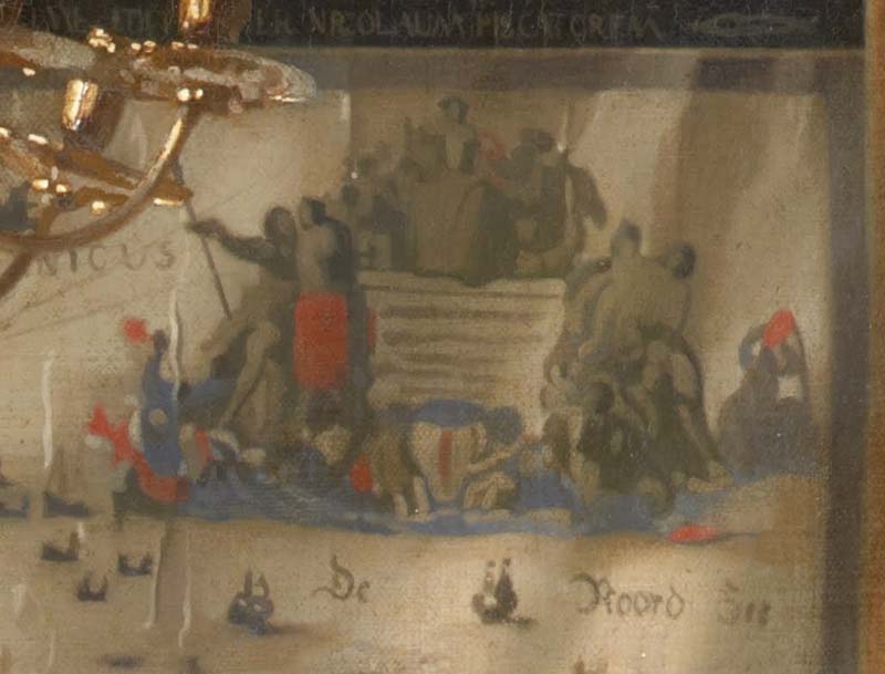
that Visscher’s simple news map of the siege of Breda can be usefully put beside
the great painting by Velazquez. The
power of the history painter’s representation
is partly derived from its relationship to a previous interpretation of a meeting.
The surrender between gentlemen, which is surprising by its intimacy in
the minds of a public occasion, was culled by Velazquez from Rubens’ Meeting of Jacob and Esau. The gestures of greeting and also the famous lances reveal
this. Despite the mapped
background Velazquez’s art contained much of what I am considering
as the northern mode), Velazquez presents a human relationship steeped in
artistic tradition, which he further stages on the basis on the basis of an
account of Breda given in a contemporary play.
Visscher’s map with accompanying text records the placing of Breda and
the lineup of the army, and indicates relevant towns, churches, rivers, and forests. He numbers with a verbal key below the
placers of interest. To record history
in maps and their related illustrations is to emphasize certain aspects rather
than others: history is pictured by
putting before our eyes an enriched description of place rather than the drama
of human events.

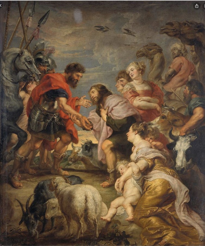
Rubens, “Meeting of Jacob and Esau”, 1624
That Rubens does make the Velasquez battle scene look very good by comparison.
Even more so, do similar paintings from about the same year.
They’re more like decorative tapestries
whose “heroes” appear more like fat buffoons.

Zurbaran, Defense of Cadiz against the English
It's hard to believe that Zurbaran was painting some his weirdly beautiful robed monks at about the same time.

Albert Eckhout (1610-1665)
In discussing descriptive painting - i.e. that which is “Terse, factual, non-interpretive ”, and is "binding knowledge to the vivid appearance of things seen", Alpers mentions the court painters of Prince Maurits who recorded life in the brief Dutch colony in northeastern Brazil.
The sharp edges of the above is certainly vivid - but isn't it more like a fantasy of African masculinity ?

While this image of a woman carrying around severed human body parts is probably a fantasy concerning savage, though attractive, cannibals who needed to be civilized.

Going in a completely different direction in the depiction of non-Europeans -- here is a portrait of a diplomat from an African kingdom. He's just a Dutch burgher who happens to have a dark complexion.

My favorite Eckhout paintings are his still life of tropical fruit.
This seems to be the only genre where I would agree that he presents:
"a surface on which a great variety of information can be collected" and where "no single view dominates" while it "offers a detached and perhaps even culturally unbiased view"

Jan Van Kessel the Elder (1626 - 1679)
"America"
I would agree -- but I also think that they were 100% Euro-view to begin with.

By the way, I far prefer Kessel's wacky seashell masks.
So tame -- and so disruptive.

Reminds me of my 8th grade math teacher
************************
 Pierre Mignard, Clio, Muse of History, 1689
************************


We can now return with a greater understanding to the splendid wall map that Vermeer gave a central place in “allegory of Painting” . Blaeu’s praise for the map that brings knowledge of history into the house is here realized before our eyes. This map which we realizes before to be like a painting is also a version of history. Vermeer confirms this for us in the female e placed just before it. The figure whose image he is beginning to enter onto his canvas as the object of his art. Draped, wreathed with bay, bearing a trumpet and a book, the young woman is decked out as the figure of History according to the recipe of Ripa. She serves as an emblematic label placed diagonally across the map from the word "descriptio:: together these two signs, the woman and the word, set forth the nature of the mapped image.
We do not think of Vermeer as a history painter. After his first works he turned away from the tradition of narrative subjects. The argument that the depiction of history's Muse shows that, despite his own art, he still honored the noblest art in the traditional sense is unpersuasive. His concentration on the domestic world of women attended by men excludes the public stage on which history in this sense takes place. The map in the Art of Painting confirms this domesticity. Far from threatening the domestic world, this pictured map takes history in to inform it. It is as if History raises her trumpet to praise such descriptive painting.
But to conclude with the map alone is not to do full justice to its place in Vermeer's "Art of Painting", of which it is only a part, albeit a central one. Consider how Vermeer not only relates but also compares Clio and the map. He has juxtaposed two different kinds of pictorial images - one, the figure of a young woman as Clio, an image replete with meaning calling for interpretation; the other the map, an image that functions as a kind of description. How does an image comprehend the world, Vermeer makes us ask, through an association of meanings (art as emblem) or through description (art as mapping)? As we step back from what is before the painter - the woman and the map - to view the artist and the world of which he is part, we too are suspended between seeking meanings and savoring lifelike descriptions.
Questions like "How does an image comprehend the world" seem more appropriate for the late 20th century academic world of Alpers than to the mercantile and pragmatic world of 17th century Netherlands. I do feel the contrast between the emblem-making artist being portrayed and the more mimetic artist who is portraying him. But being more of an aesthete than a philosopher, I'm not "suspended" between seeking meanings and savoring description. For me, they are inseparable.
The emblematic figure, Vermeer acknowledges, is but one of his familiar models dressed up to represent History. She poses, taking on a role. On the table, the fabrics, books, and the mask - whatever they might be said to mean - are the very materials out of which an emblematic identity is composed. The are discarded or perhaps waiting to be assumed. Vermeer juxtaposes the face of the woman with the map. Her eyes, nose, mouth, and her curls are placed beside the bridges, tower, and building of one of the small town views, while behind her head lies the Netherlands. The mapping of town and of country are compared to the delineation of a human visage. This may be the most extraordinary transformation of all. It recalls those simple woodcuts with which Apianus illustrated Ptolemy's analogy between describing the world and picturing a face. But Vermeer disclaims an identity. In contrast to Ptolemy and Apianus, Vermeer distinguishes the human presence from map or city. He shows instead that inscription and craft, like emblematic accouterments, give way before the flesh of a human presence.
Every kind of image gives way to depictions of a human face. It's the most critically important visual phenomenon that human eyes ever look at. Sometimes a matter of life and death.

Apianus - depicting an analogy made by Ptolemy
But that is not final, for craft is richly present in this painting. A crafted world surrounds both artist and model, who are introduced by a tapestry backed by a map, crowned by a splendid chandelier, and richly robed. Craft subtly transforms and shapes observation. Observation is in fact revealed to be inseparable from craft. The leaves resting on the model's head are both reconstituted by the painters brush and transformed in thread high on the foreground tapestry. There too they grace a female figure, though one woven in cloth - the only legible human form in the tapestry. The golden band on the woven woman's dark skirt recalls, though in reverse, the pattern and colors of the skirt of the artist's Muse. A woman too is subject to fabrication.
What about beauty? Isn’t that also richly present in this painting? And aren’t there more than enough examples of well crafted things that are not especially beautiful? (which might serve as a definition of mediocrity)
As a contemporary art historian, Alpers refuses to discuss aesthetics - even if nothing else could explain why this painting has been the object of so much attention in this chapter -- as well as the world of art.

Vermeer signed the map and paints the woman. The eroticism of his earlier works - where men wait attentively upon women - is absorbed here into the pleasure of representation itself, which displayed throughout the painting. Vermeer withdraws to celebrate the world seen. Like a surveyor, the painter is within the very world he represents. He disappears into his task, depicting himself as an anonymous, faceless figure, back turned to the viewer, his head topped by the black hole of this hat at the center of a world saturated with color and filled with light. We cannot tell where his attention is directed at the moment: is it to the model or to his canvas ? Observation is not distinguished from the notation of what is observed. That is the grand illusion that the picture also creates. It presents an Art of Painting that contains within itself the impulse to map.
Why must we assume that this is a self portrait? Vermeer was not making emblematic paintings at that time, was he? And isn’t there an enormous difference between the visual quality of the map depicted in the background and the Vermeer’s painting of it? It’s folds are visually more important than anything drawn by the mapmaker.
The Art of Painting contains within itself the impulse to make the perceivable world appear
beautiful, energized, thrilling, and enchanting. Or, at least, that's how a screen size reproduction appears to me. Never having seen the original -- or a full sized, 48" high reproduction, I hesitate to say much else about it.
Considering his other work, it appears that Vermeer mostly painted to present his world as he loved it: his city, his street, the rooms of his upscale house, and especially, as in this painting, his studio. So the "Art of Painting" is not especially about him or a theory of art as symbol or description. He loves that studio, its props, its models, its light, and waves of energy emanate from the artist portrayed working in it.
B.T.W., the topic of this chapter reminds me of an encounter I had nearly fifty years ago with a metal figure sculptor and professor of art at Buffalo State University. (I believe his name was Tony Paterson). I was not a student there, but somehow I did end up in his studio to hear him proclaim that mimetic figure sculpture was “mere map-making”. Perhaps he would have allowed that Rodin and Michelangelo were exceptions - but still - I do believe that he was voicing an attitude trending in the academia of that time. It does not appear to be trending today, where mapmaking, as Alpers presents it, is a credible approach to knowledge - even if - or especially since -
aesthetics are not involved.
No comments:
Post a Comment